One of my favorite corny movies is “Overboard,” starring Goldie Hawn and Kurt Russell. Hawn plays a wealthy yacht owner, while Russell, her partner in real life, portrays a small-town carpenter brought to the yacht for repairs. Hawn, unsatisfied with Russell’s work, throws him and his tools overboard. Later Hawn falls overboard, strikes her head, and washes up on the edge of town, still alive. But as she struggles with amnesia, Russell takes advantage of Hawn’s character until she regains her memory. In one pointed scene late in the movie, Rodney McDowell, as her butler, tells her she has gained an important gift: viewing life from both sides of a table.
This long introduction is how I have felt about development along our waterfront and the way it is handled by the Plymouth Historic District Commission. I have had the opportunity to sit at the board’s table – both as a commissioner and as a presenter of projects. As a board member I have respected another architect’s vision while upholding the guidelines for the district. On the flip side, I have presented projects that are the dreams of building owners, only to have the HDC not agree with our vision.
One thing I have always been adamant about is the protection our ever-evolving historic district deserves while accommodating growth and change. It has over 400 years of history and building, and it’s common for a lot to have had six to seven (see what I did there?) previous buildings. This has never been more apparent than on our waterfront.
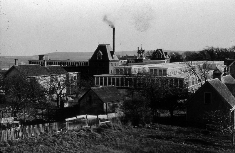
Plymouth’s waterfront has undergone enormous changes. I groan when people assume it’s always looked the way it does now. Less than 75 years ago, two massive factory complexes sprawled across our waterfront.
The current 71 Degrees restaurant is in the lone survivor building from the mill complex once stretching from Brewster Street to Chilton Street and west almost to Court Street.
Mabetts Worsted Mill occupied part of the site into the 1950s. The area now home to the Village Landing, Hotel 1620, Citizens Bank, and various parking lots was once the home of Puritan Mills, a combination of wooden and brick structures as much as four stories tall surviving until the early 1970s. What’s more, a power generating plant sat at the entrance to Brewster Gardens in the location of the current pergola.
If the clock were turned back to the years before 1920, our waterfront would be even more unrecognizable. In 1920, there was a large-scale waterfront clearing project to prepare for the Tercentennial celebrations. Removed were the large industrial buildings and multiple wharves then dominating the scene. The massive brick power plant for the Plymouth and Brockton Street railway was 22 feet high with a 130-foot chimney. The plant was located at the current public restrooms on the State Pier. Just south of the plant were several coal storage buildings known as bunkers. They were large narrow buildings; one rose at least 30 feet while an overhead train trestle connected two of the buildings.
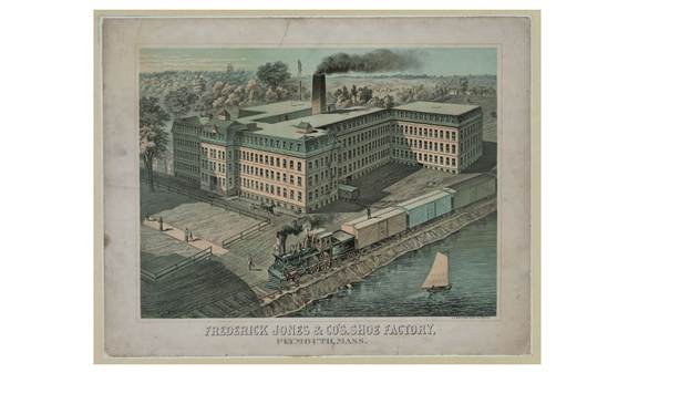
On the opposite end of the waterfront, at the location of the current Enterprise Car Rental building on North Park Avenue, was the five-story Emery Shoe factory. The building was over 150 feet long and 35 feet wide with two wings of comparable size. The Harbourtown building, the object of many complaints about blocking views of the waterfront, pales in comparison to this behemoth.
Turning the clock back another hundred years reveals the image of a waterfront unrecognizable to the residents of the early 20th century. In 1830, the train had not yet arrived in Plymouth and small wooden buildings supporting the shipping trade littered our waterfront in haphazard fashion. Water Street did not exist beyond North Street and the largest wharf, Long Wharf, extended almost to the current breakwater. Plymouth Rock was barely visible and incorporated into one of the smaller wharves.
Go back another century and the 1701 map of Plymouth shows a barely developed waterfront. One small cart way connected East Street (Leyden) to the “new” street (North). A single small pier existed close to the mouth of the Town Brook, which at the time was several times wider than the small outlet of today. The waterfront, north of the new street, was labeled Howland Land.
For the Pilgrims, the waterfront represented an area to graze pigs. One account describes the native people complaining to the colonists about swine destroying shellfish beds important to survival. The waterfront was nothing more than a landing point for incoming ships and departure point for fishing boats. Early town development focused on and around the Town Brook.
Four hundred years after the Pilgrims landed on a site that probably looked a lot like the area north of Nelson Park today, our waterfront is a mix of pastoral parks, tourist sites and commercial entities. Our waterfront is less developed now than it was prior to the 1920 clearing.
When a new project is proposed, all I hear is the rally calls flooding social media: “No more building.” I wish folks would pause and do a little research first. That’s what I do before presenting a project to the HDC. The history of a project site is important knowledge to all the parties involved.
A perfect example is the Cooper Cove Village project on the northern edge of the waterfront. Located on a former manufacturing lot, the land was so contaminated it had been abandoned for years. Once cleaned up, though, it has been turned into a residential complex, a much-needed addition to Plymouth’s lagging housing stock.
The former Governor Bradford hotel is yet another example. As late as 1879, Brewster Street did not exist, and the land was underwater. Once the land was filled, the first building to occupy the site, in 1885, was a guest house; mill buildings followed. The motel, built for seasonable use only, was erected in the mid ’60s. Several proposed developments failed when the high-water table derailed plans. The motel was re-envisioned as rental apartments occupied mainly by Plymouth residents, while the lower floors are now populated with businesses filling a historic retail gap along that stretch of Water Street.
Currently, there is a major project underway at the southern end of our waterfront. When it was first proposed, the neighborhood banded together to oppose the project. The project involved removing an historic foundry dating to the middle of the 19th century. In the end the project moved forward, but out of the ashes of the demolition arose an expansion of our historic district to include the southern end of our waterfront as well as a good portion of Union Street and Lincoln Streets.
The loss of these historic foundry buildings may have been tragic, but if the residents of the 1850s had a chance to speak, they would tell tales of constant noise, smoke from coal fired furnaces, and unending industrial waste.
This is all part of the evolution our waterfront has undergone in its 400 years of history. In the future when a development project is proposed on the waterfront, pause and consider the site’s history. The past may have been far worse.
Architect Bill Fornaciari is a lifelong resident of Plymouth (except for a three-year adventure going West as a young man) and is the owner of BF Architects in Plymouth. His firm specializes in residential work and historic preservation. Have a question or idea for this column? Email Bill at billfornaciari@gmail.com.