Have you ever had your plans for the day suddenly changed? Well, that happened to me not long ago when, just as I was walking into the gym, I received an email from Conor Anderson, Plymouth’s historic resources coordinator, who had just discovered a mislabeled file at Town Hall.
Originally labeled as documents from the 1980s, Conor said the file actually contained about 80 previously unknown photographs of buildings from the end of the 19th century. Now that might not send everyone running to Town Hall, but for me, it was a gift from heaven. Needless to say, my workout was derailed.
If you are a newcomer to Plymouth, you may recognize only a handful of the landmarks depicted. A native Plymouthean will be able to identify perhaps a dozen or more. Dedicated Plymouth historians may get most of them, but even I, with my lifelong obsession with Plymouth’s historic architecture, was unable initially to figure out three of them. It’s those three that I’m writing about here.
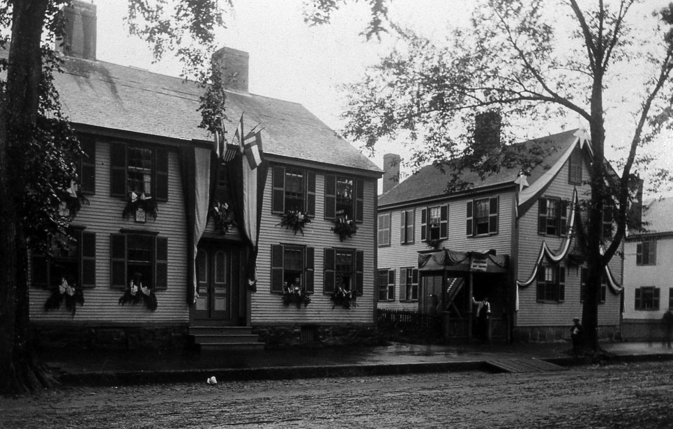
The first photo that tripped me up features two buildings. (It’s shown under this column’s headline.) The photo angle almost looks like the two buildings are located at an intersection.
The buildings are decorated for the holidays, most likely the 4th of July. Upon further investigation (and wearing my reading glasses) the buildings are separated by a large yard. The building on the right provided the clue for their identification.
Colonial architecture in New England was commonly based on symmetry, often with two windows placed on either side of a centrally located front door. This arrangement is known as a five-bay building, each window and door opening representing a “bay” that usually reflects the timber framing hidden behind the sheathing. Our mystery building, however, is asymmetrical.
Instead of a balanced facade, the front door is not centered. One window is to the left of the front door, while there are two to the right side of the door. The building is a rare four bay building, often known as a ¾ house. The unusual style allowed me to identify it as a house at 66 Court St.
Incidentally, the building’s front door does not face the street. Perhaps a small lane was once present or the building may have been moved at some point in the past. Clues indicating a move may be found in the foundation, which is orderly cut stone granite blocks rather than rubble stone. It’s these foundation stones that help identify the building’s location.
The MACRIS (Massachusetts Cultural Resource Information System) report for the structure claims this building was constructed in 1910 but the massive central chimney points to a construction in the 18th century. A deeper dive into this building – with an internal investigation of the attic and basement – would help determine the building’s real age. With the building on the right identified, it is now possible to recognize the radically altered building on the left as 60-62 Court St., which is the current home of clothing store Style Unlimited.
Originally known as the Nelson Bacon house, it was constructed between 1781-1785 and has been extensively renovated since the photo was taken. At some point in the 20th century, the first floor was removed and lowered to street level, the chimneys were demolished, and a third floor was added.
Despite all the changes, the identity is confirmed because the second floor window arrangement remains the same.
The next unidentified building took me some time.
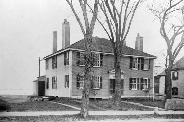
Our second mystery guest is a five bay symmetrical hipped-roof federal colonial with four chimneys that features views out to a waterway. I was stumped after my first guess of 2 Stephens Lane proved a bust. The Stephens Lane building has been severely altered but the building form matches the photograph, and the rear yard does face out towards Plymouth Harbor. What doesn’t match is the building to its right. Cross referencing old maps, the Stephens Lane house never had a building on its right side.
I then considered 26 North St., but too many discrepancies ruled that out, too. The clue was the water views to the left of the house. I continued my search on the stretch of Sandwich Street south of Fremont Street. Commonly known as Gasoline Alley and close enough to Plymouth Harbor to provide water views, I considered the possibility that the house was removed from that stretch of road after the photo was taken. But after several hours of consulting old maps, it was apparent that no houses built there matched the footprint of the mystery building.
I was about to give up when Plymouth reference librarian Julie Burrey suggested the house may be in North Plymouth. I once again began the search by cross-referencing several antique maps. Beginning at Knapp Terrace, I slowly progressed north. Huge portions of land were easy to dismiss: the North Plymouth business district along with areas adjacent to Cordage Park. Eventually, the search crossed into Kingston with no match, making the antique Plymouth maps that stopped at the border no longer helpful.
Before giving up, though, I switched to the Google satellite map, progressing north until I found a hip roofed structure. Google Street View indicated a large S tie rod on the north brick facade. Eureka! Known as the Delano House, it was built prior to 1800 and is located at 87-89 Main St. in Kingston.
But what about mystery house three? There I came up empty – at least so far. And perhaps that’s where one of my readers may be able to solve the puzzle.
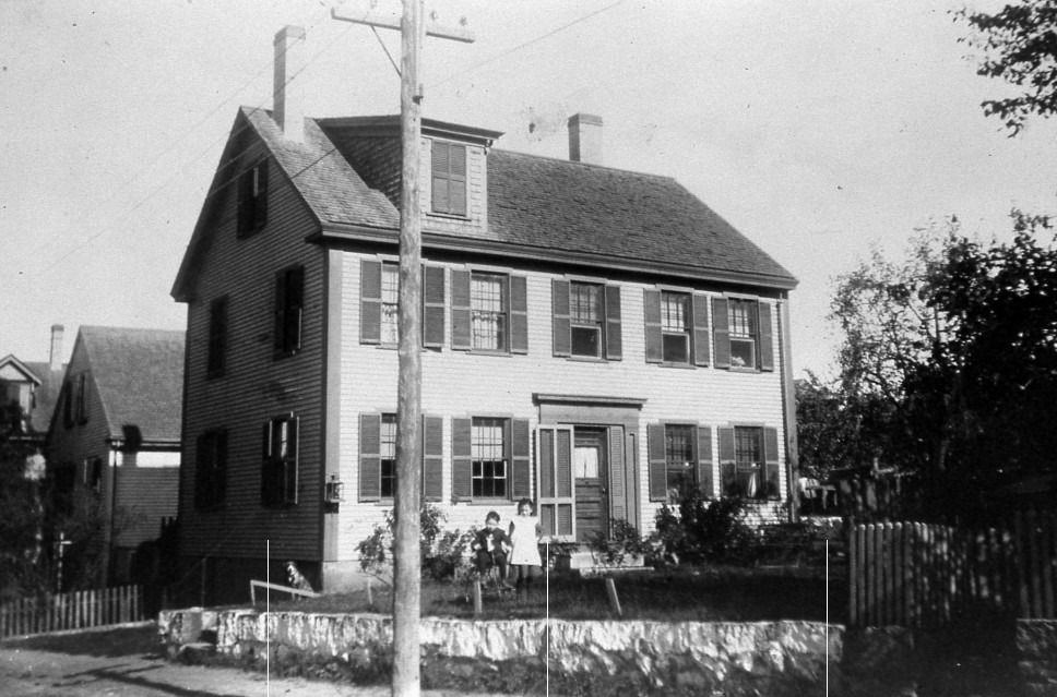
There are three distinct features in the photo that provide clues: the dormer, the stone wall out front, and the dormer on the house to the far left. The stone wall and its slight curve on an uphill slope first led me to South Street, as it curves to the left in the vicinity of Mayflower and Stafford Streets. That’s an area where the current homes were built in the 1920s – perhaps the house was destroyed and replaced. But cross referencing with old maps revealed no matches.
I then searched the streets in the Training Green neighborhood and again failed to solve the puzzle. In my next attempt, I studied multiple photos of the long-destroyed Summer Street Redevelopment Authority area. No luck.
And now, after several weeks of searching multiple Plymouth neighborhoods, I have come up short. Perhaps someone will recognize the house or maybe the children out front.
Do you know mystery house three? But a fair warning . . . just as your math teacher required in high school, you need to show me your work and provide evidence to support your theory. Can someone beat me at my own game? I hope so.
Architect Bill Fornaciari is a lifelong resident of Plymouth (except for a three-year adventure going West as a young man) and is the owner of BF Architects in Plymouth. His firm specializes in residential work and historic preservation. Have a question or idea for this column? Email Bill at billfornaciari@gmail.com.